Datanami
 EnterpriseAI
 HPCwire Japan
 QCwire
 HPC & AI Wall Street
September is Supercomputing Month at the Department of Energy (DOE), so the government labs are showcasing some of the ground-breaking research that’s come about thanks to advancements in HPC technology and expertise. While it’s difficult to think of a scientific discipline, or even an academic field, that has not benefited from the enabling boost of souped-up computational power, climate research stands out as being particularly dependent on these compute and data-intensive capabilities.
 What makes climate change unique is the necessity for large-scale models that have multiple variables, each complex in their own right. These elements include sea temperatures, sea currents, sea ice, the interaction between the surface of the ocean and the atmosphere, air temperatures over land and the impact of clouds. A supercomputer has to take into account all these factors, and more, and calculate all the possible ways they can interact. Simulations can tie up the biggest supercomputers in the world for weeks at a time. The scope and necessity of such an endeavor is matched only by the largest of supercomputing centers, which in the US, means the DOE labs.
As the primary scientific computing facility for the DOE’s Office of Science, National Energy Research Scientific Computing Center (NERSC) – a division of the Lawrence Berkeley National Laboratory – is one of the largest facilities in the world dedicated to basic science research. A sizable portion (12 percent) of the supercomputing resources at NERSC is allocated to global climate change research. That’s nearly 150 million processor-hours of highly-tuned computational might focused on an issue that is critical to humanity’s future.
With each generation of supercomputers exponentially more powerful, climate models grow increasingly detailed. Science Writer Jon Bashor notes that the best global models of the late 1990s treated the western United States from the Pacific Ocean to the Rocky Mountains as a uniform landmass, even though there are topological features, like mountains, deserts and bodies of water, that affect climate. With the advances in hardware and software over the last two decades, today’s models have improved resolution down to 10-kilometer square blocks, while the next generation will drill down to the 2-kilometer level. The more fine-grained the models become, the more accurate the predictions will be.
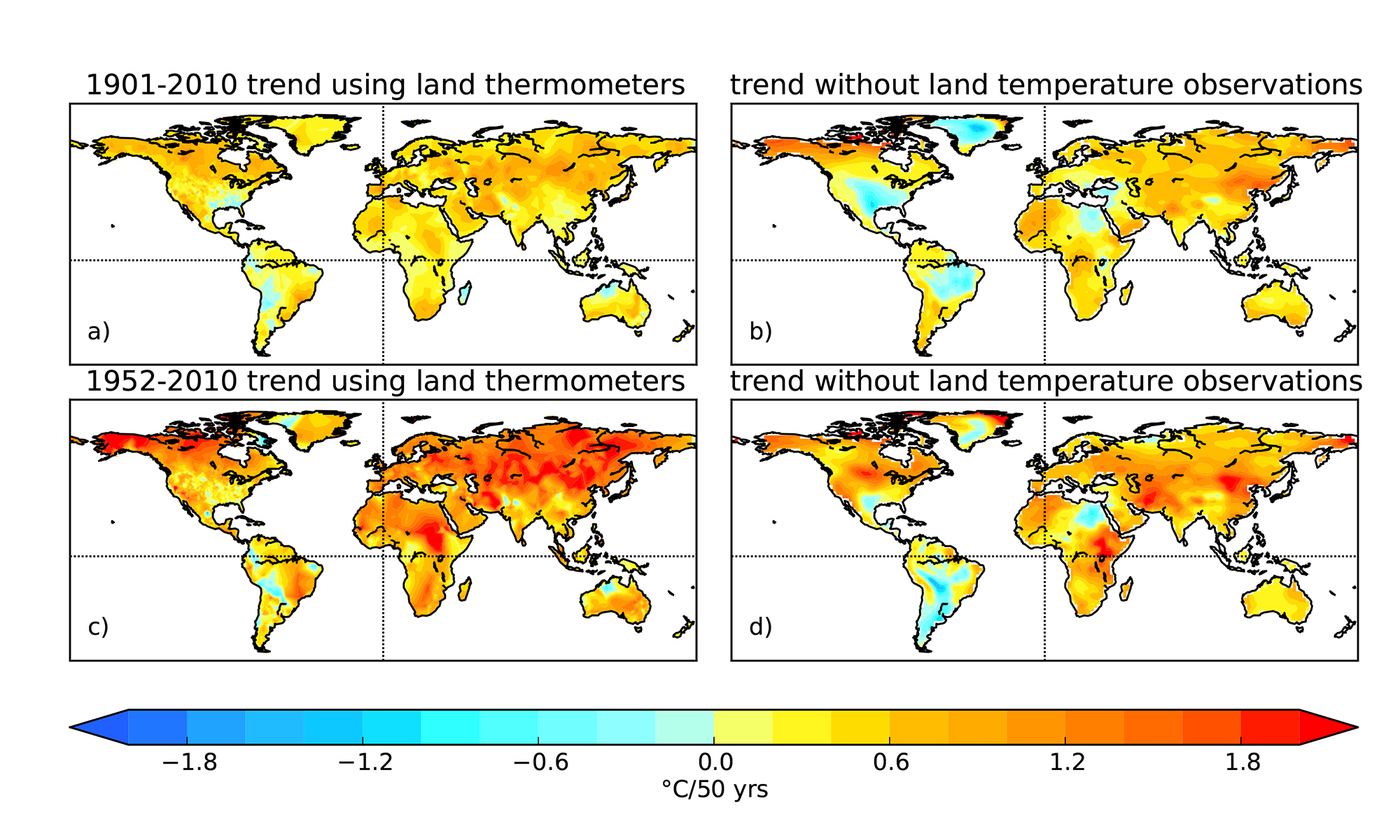
Climate change is one of the most pressing issues facing our planet today, so accuracy is extremely important. People want to know if the models can be trusted and to what degree. Confidence is especially critical in estimates of anthropogenic climate change. Models are often vetted by checking certain scenarios against real-world results. A common evaluation technique is to “predict” climate sequences that have already occurred. This kind of backwards-looking analysis was taken on by the 20th Century Reanalysis Project, under the leadership of Gil Compo of the University of Colorado, Boulder, and the National Oceanic and Atmospheric Administration’s (NOAA) Earth System Research Laboratory. The project was awarded 8 million processor-hours at NERSC.
The project relies on a database of extreme global weather events from 1871 to the present day, culled from newspaper weather reports, measurements on land and sea for the first decades, and then as technology evolved, there were more detailed measurements from aircraft, satellites and other sensors. The team of top climate scientists fed the data into powerful supercomputers, including those at NERSC and the Oak Ridge Leadership Computing Facility in Tennessee, to create virtual climate time machine.
Click on image to reveal full-sized graphic.
Simulations based on the model showed a remarkable degree of prescience. “The model accurately predicted a number of extreme weather conditions, including El Niño occurrences, the 1922 Knickerbocker snowstorm that hit the Atlantic Coast (causing the roof of the Knickerbocker Theater in Washington, D.C., to collapse, killing 98 people and injuring 133), the 1930s Dust Bowl and a hurricane that smashed into New York City in 1938,” reports Bashor.
The “predictions” were not only possible, but were calculated with great accuracy. Compo and his team had constructed a map of the the earth’s weather and climate variations since the late 1800s. The next step was using the data assimilation system for real predictions – specifically to anticipate future warming patterns.
As recently reported in Geophysical Research Letters, ongoing research carried out under the 20th Century Reanalysis Project has yielded independent confirmation of global land warming since 1901, providing further evidence of anthropogenic global climate change. Up to this point, the case for global climate warming rested on long-term measurements of air temperature from stations around the world. The Reanalysis Project, however, draws on other historical observations, including barometric pressure from 1901-2010.
“This is really the essence of science,” says Compo. “There is knowledge ‘A’ from one source and you think, ‘Can I get to that same knowledge from a completely different source?’ Since we had already produced the dataset, we looked at just how close our temperatures estimated using barometers were to the temperatures using thermometers.”
The 20th Century Reanalysis Project has been instrumental in boosting the confidence in estimates of past, present and future climate change, according to Compo. And because key variations and trends line up with traditional climate models, it increases the robustness of conclusions based on those data sets.
“If, for some reason, you didn’t believe global warming was happening, this confirms that global warming really has been occurring since the early 20th century,” notes Compo.
Related Items
DOE Supercomputer Hack Results in Guilty Plea
One Step Closer to Fusion Energy
Researchers Squeeze Record I/O from Hopper
NERSC Managers Shed Light on ‘Edison’