Datanami
 EnterpriseAI
 HPCwire Japan
 QCwire
 HPC & AI Wall Street
For the first time in human history, more than half of the world’s population lives in urban areas, and that trend is only picking up steam: in 2018, the UN estimated that 68 percent of the world would live in urban areas by 2050. Keeping those cities safe and sustainable is an increasingly urgent priority for urban planners, who are beginning to leverage next-generation technologies to assist in planning increasingly ambitious and data-driven environments. Now, researchers from the NSF’s NHERI SimCenter have developed an analysis suite to help users identify the resilience of city structures.
The SimCenter – which studies natural hazards engineering – calls the suite BRAILS, for Building Recognition using AI at Large-Scale. BRAILS combines machine learning, deep learning and computer vision to study satellite and street-level imagery and evaluate building characteristics and assess risks from natural disasters.
“We want to simulate the impact of hazards on all of the buildings in a region, but we don’t have a description of the building attributes,” explained Charles Wang, lead developer of BRAILS, in an interview with Aaron Dubrow at the Texas Advanced Computing Center (TACC). “For example, in the San Francisco Bay area, there are millions of buildings. Using AI, we are able to get the needed information. We can train neural network models to infer building information from images and other sources of data.”
Training BRAILS’ modules – and running the ensuing risk simulations – required substantial computing power. For that, Wang and his team turned to TACC, where they used the Frontera supercomputer. Frontera’s 23.5 Linpack petaflops of computing power placed it ninth on the most recent Top500 list of the world’s most powerful publicly ranked supercomputers. The researchers also used Maverick 2, a GPU-driven system that specializes in deep learning.
“The hazard event simulations – applying wind fields or ground shaking to thousands or millions of buildings to assess the impact of a hurricane or earthquake – requires a lot of computing resources and time,” Wang said. “For one city-wide simulation, depending on the size, it typically takes hours to run on TACC.”
The team is hard at work expanding BRAILS: they recently released version 2.0, which expanded the list of building characteristics, and launched a citizen science project on Zooniverse to solicit labeled data such as roofs, windows and chimneys from volunteers online. “We launched the Zooniverse project in March and within a couple of weeks we had a thousand volunteers, and 20,000 images annotated,” Wang said.
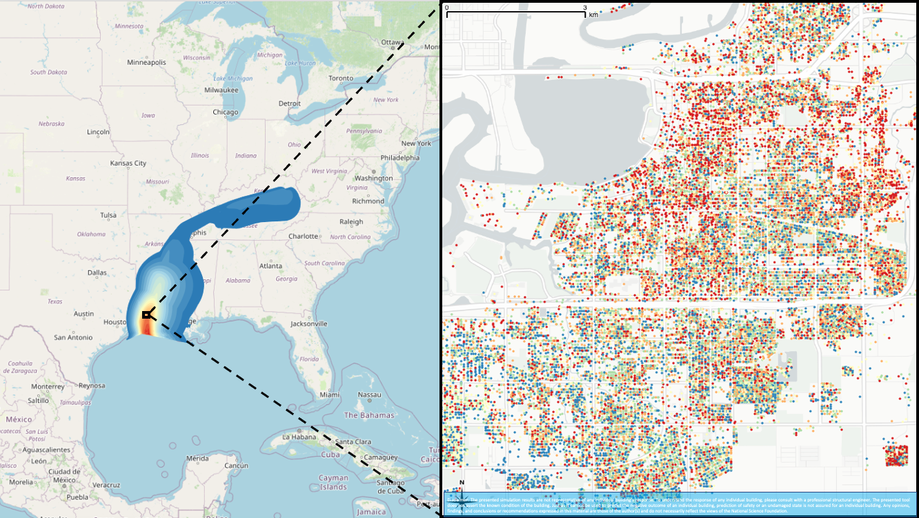
The researchers have tested BRAILS using scenarios in various cities – including earthquakes in San Francisco and hurricanes in Louisiana, New Jersey and Texas – and report 90 to 100 percent accuracy in terms of evaluating many building characteristics.
To learn more, read the coverage from TACC’s Aaron Dubrow here.